Gateway Activation Project (GAP)
Project Information:
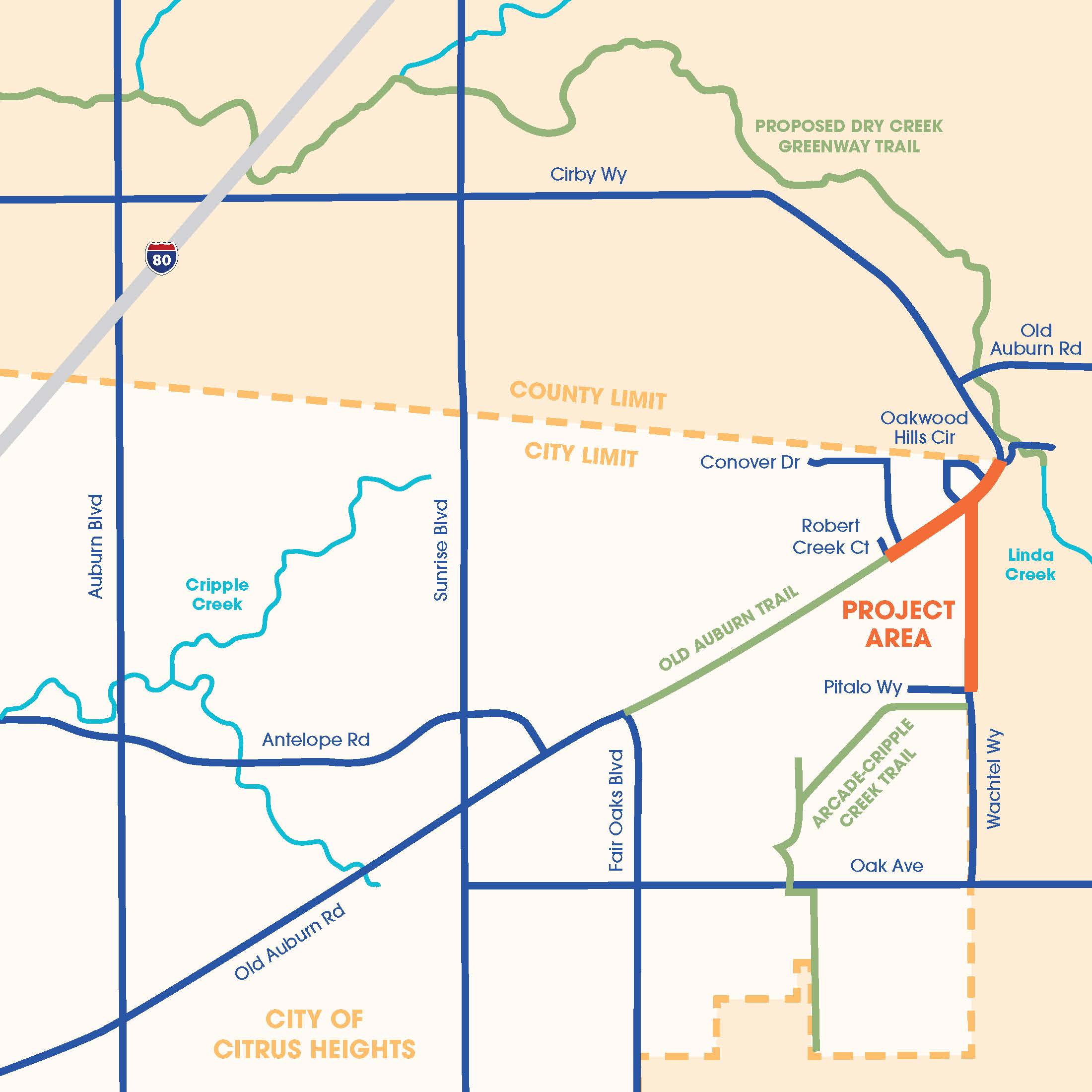
On May 13, 2026, the City Council approved the Gateway Activation Project (GAP), a transportation improvement initiative that will implement multimodal and roadway enhancements along Old Auburn Road and Wachtel Way. The project will connect to existing bicycle and pedestrian facilities and establish future trail connections to planned regional improvements in the City of Roseville and unincorporated Sacramento County.
The project is designed to advance Complete Streets improvements that enhance safety, improve traffic operations, and expand mobility and accessibility for all users, including pedestrians, bicyclists, motorists, and transit users.
The approved improvements will help provide residents with safer and more convenient access to neighborhoods, parks, open spaces, residential areas, and regional trail networks both within and beyond City limits.
City Council approval also establishes the necessary framework for the City to pursue future grant funding opportunities and advance the project into the next phase of design and engineering.
Project Objectives:
- Complete Street design for Old Auburn Road and Wachtel Way
- Extension of multi-modal facilities on Old Auburn Road to the city’s northern border
- Extension of multi-modal facilities on Wachtel Way to the Old Auburn Road intersection
- Intersection improvements at Old Auburn Road/Wachtel Way and Old Auburn Road/Oakwood Hills Circle
- Pedestrian crossing and safety improvements at Old Auburn Road and Argo Drive
Planned Improvements:
- Wachtel Way: The bicycle/pedestrian improvements along Wachtel Way will extend from just south of Pitalo Way at Arcade-Cripple Creek Trail to Old Auburn Road. The multi-modal trail will be located on the west side of Wachtel Way.
- Old Auburn Road: Bicycle/pedestrian improvements along Old Auburn Road will extend from Auburn Oaks Village Lane on the west to the Placer County line on the east. The multi-use trail will cross at Argo Way and continue along the south side of Old Auburn Road to the Roseville City Limits and future Dry Creek Greenway.
- Intersection improvements at Argo Drive/Old Auburn Road will evaluate adding a pedestrian crossing and enhanced safety features.
- Intersection improvements in three locations (Oakwood Hills Circle, Wachtel Way, and Oakwood Hills Circle/Linda Creek Ct) were evaluated. The project team evaluated various intersection treatments to improve safety, reduce delay, and provide trail connectivity along the corridor. Ultimately, the use of single lane roundabouts at each of the three intersections best achieves the project objectives of improving safety and circulation and providing trail connectivity.
View City Staff's Gateway Activation Project Presentation Deck
Below is an image of the Gateway Activation Project Plan improvements. Click to enlarge the image.
Community Outreach & Agency Coordination:
Community outreach and engagement will be vital for this effort, and the team has prepared an engagement plan that includes creating an outreach toolkit, several pop-up events, two community workshops, and updating the project website.
Flyers/fact sheets will be prepared in multiple languages and distributed via direct mail as well as at the project events.
- The first Community Workshop was held on April 29, 2025, at Big Oak Mobile Home Park. View the Workshop Meeting Summary here .
- A pop-up event was held along the Old Auburn Trail on May 7, 2025
- The City Council reviewed project alternatives at their meeting held on June 25, 2025 (see below for meeting info)
- A community workshop to review the environmental document was held on March 5, 2026 Workshop Meeting Summary here .
Project Timeline:
Past Meetings
A meeting before the City Council was held on May 13, 2026. At this meeting, the City Council approved the Project and adopted the Mitigated Negative Declaration, the Mitigation Monitoring Plan, and the updated Bikeway Master Plan, Pedestrian Master Plan, and General Plan Bikeway Map for the GAP project.
On April 14, 2026, the Planning Commission reviewed the environmental reports and forwarded a recommendation of approval to City Council. To review the Planning Commission Staff Report please visit: Planning Commission
On June 25, 2025, City Council received an update about the GAP and provided direction to begin the project’s environmental review and preliminary engineering. Watch the presentation here Project Timeline: Project Timeline: Project Timeline: Project Timeline: Project Timeline: Project Timeline: Project Timeline: Project Timeline: Project Timeline: Project Timeline: Project Timeline: Project Timeline: Pas Past Met Past Meeting Past Meetings. Review the presentation slides here Project Timeline: Project Timeline: Project Timeline: Project Timeline: Project Timeline: Project Timeline: Project Timeline: Project Timeline: Project Timeline: Project Timeline: Project Timeline: Project Timeline: Pas Past Met Past Meeting Past Meetings.
- The current timeline comprises traffic studies, environmental clearance, utility coordination, engagement, and right-of-way acquisition. On Tuesday, April 14, 2026, the Planning Commission will review the environmental reports and forward a recommendation to City Council. To review the Planning Commission Staff Report please visit: Planning Commission
- The City will apply for grant funds in 2027.
- Construction plans, specifications and estimates are scheduled to be completed in early 2028, with construction set for Spring 2028 (pending funding).
Environmental ReviewThe City prepared an Initial Study (IS) to evaluate the potential environmental impacts of the Gateway Activation Project. Based on the analysis, the Initial Study determined that an Initial Study/Mitigated Negative Declaration (IS/MND) is the appropriate environmental document for the proposed Project. The Draft IS/MND was available for the required 30-day public review period beginning at 8:00 a.m. on Friday, February 13, 2026, and closing at 4:00 p.m. on Thursday, March 19, 2026. A public meeting was held on Thursday, March 5, 2026, at 5:30 p.m. at Big Oak Mobile Home Park, located at 8300 Old Auburn Road, to present the findings of the Draft IS/MND. The Final IS/MND was reviewed by the Planning Commission on Tuesday, April 14, 2026. The Planning Commission forwarded a recommendation to approve the project to the City Council. The City Council approved the project and adopted the associated environmental documents on Wednesday, May 14, 2026. |
Resources & Documents
- What is the Gateway Activation Project (GAP)?
-
The Gateway Activation Project (GAP) is a planned transportation and infrastructure improvement project focused on Old Auburn Road and Wachtel Way in Citrus Heights. The project will implement multimodal (walking, biking, transit) and roadway improvements to create a Complete Streets environment that enhances safety, accessibility, mobility, and regional trail connectivity. It aims to connect existing and future pedestrian and bike facilities, including local multi-use trails and those in neighboring Roseville and Sacramento County.
- What phase is the project in?
-
The project is currently in the preliminary engineering and environmental review phase. Previously, the alternative analysis and selection phase was completed, which culminated in a comprehensive presentation to City Council in 2025, where Council approved the current concepts and directed staff to move forward into the current phase. To hear the details of the alternative analysis, please click the following link to watch the Council presentation: https://www.youtube.com/live/DLhEaVjIYQU?si=o-hr0fLC40X4RACo&t=2681
The current phase is expected to continue through the environmental clearance process into Spring 2026.
- I see that a Mitigated Negative Declaration (MND) was prepared for this project’s environmental review. What is an MND?
-
An MND, or Mitigated Negative Declaration, is a document prepared for a project undergoing environmental review under the California Environmental Quality Act (CEQA). It states that although the project may have significant environmental impacts, those impacts can be avoided or mitigated to a level of insignificance through specific measures. Essentially, an MND indicates that with the implementation of defined mitigation strategies, the project will not have a substantial adverse effect on the environment.
- What Mitigation Measures are included in the MND?
-
The GAP mitigation measures aim to minimize environmental and community impacts during project implementation. They address air and water quality, noise control, biological resource protection, and public safety through best management practices and monitoring.
Examples:
- Air Quality: Apply dust suppression techniques and use low-emission equipment during construction.
- Noise Control: Limit work hours and employ noise-reducing machinery near sensitive areas.
- Biological Resources: Conduct pre-construction wildlife surveys andestablishprotective buffers around sensitive habitats.
Refer to the MND for full list of mitigation measures
- When will the project go to construction?
-
Construction would occur following environmental approvals, final design, and the securing of grant funding. While the City is actively advancing design and environmental clearance to remain competitive for future grant opportunities, no construction funding has been identified at this time. As a result, the timing of construction will depend on the availability and award of grant funding and is anticipated to be several years away.
- How was the current Phase funded?
-
The current preliminary phase is funded solely by a state appropriation secured through then-Assemblymember Ken Cooley’s office. In 2022, the State General Fund allocated approximately $700,000 for GAP’s early engineering and outreach work. These funds were transferred to the city through an agreement with Caltrans and must be used for this project’s pre-construction activities by April 2026.
The money received through the state appropriate cannot be used for any other purpose.
- What are the primary objectives of the project?
-
The Main Goals of the GAP include:
- Create trail and active transportation connections along the Old Auburn Road and Wachtel Way corridors.
- Improve connectivity between local neighborhoods, the regional trail network, and neighboringjurisdictions.
- Complete planning, engineering, and environmental work needed to position the project for grant funds for future construction.
- Enhance safety for all roadway users, including pedestrians, bicyclists, and drivers.
- Evaluate and implement traffic operation enhancements at the existing dual all-way stops at Wachtel/Old Auburn and Oakwood Hills/Old Auburn.
- Support multimodal access consistent with Complete Streets principles.
- Provide opportunities for gateway features at a key entry point into theCity.
- Why does the project include roundabouts?
-
Roundabouts are proposed to address existing operational and safety challenges at key intersections along the corridor. Under current conditions, intersections controlled by dual stop signs experience long vehicle queues, inefficient operations, and driver confusion. Currently, Stop sign violations and excessive speed are commonly reported at and near these same intersections, particularly during peak periods. These locations also present challenging and uncomfortable pedestrian crossing conditions, with limited opportunities and long crossing distances.
Roundabouts improve traffic flow by reducing conflict points and vehicle delay, calm traffic speeds, and create shorter, more predictable pedestrian crossings, making it easier and safer for people walking and biking to move through the corridor. In addition, because roundabouts reduce frequent stopping and starting, a reduction in traffic-related noise is a probable outcome. They also better support trail connections and provide opportunities for gateway features that help define entrances into the City.
- What are future trail connection opportunities?
-
The Gateway Activation Project is a key link in a broader, long-planned regional trail network. The GAP will connect the recently opened Arcade-Cripple Creek Trail to the Old Auburn Road Multi-Use Trail, creating a connected trail corridors through Citrus Heights.
Outside the City of Citrus Heights, Sacramento County’s Bikeway Master Plan anticipates additional trail construction east of Citrus Heights towards the American River trail. The Sacramento County Bikeway Master Plan is available here: http://www.sacdot.com/Documents/A%20to%20Z%20Folder/Bikeways/SCBMP_North_Wallmap_Rev4.pdf (Note: this is a very large file and may take several minutes to download depending on connection speeds.)
In addition, the future City of Roseville Dry Creek Greenway East project terminates on the eastern end of Old Auburn Road, at the limits of this project. The Dry Creek Greenway connects to the west through downtown Roseville, under Interstate 80 and ending at Cook Riolo Road and further west in Placer County.
Together, these trails connect to key locations necessary to achieve a regional vision of a linked system of off-street trails that ultimately provides a continuous, low-stress route between points north in Roseville to Folsom Lake.
By closing critical gaps and improving crossings and intersections, the project strengthens regional recreation, commuting, and mobility options for people walking and biking of all ages and abilities.